Climate and Sustainability
General Insurance
Returned of the Damned Child: How is Climate Change Reshaping ENSO?




Claim your CPD points
Part One explained how ENSO events are declared and predicted, and unpacked common misconceptions about their impact on rainfall, floods and bushfires. Part Two turns to how climate change is reshaping ENSO itself, and what the current El Niño event means for the Asia-Pacific region over the second half of 2026.
Although ENSO is the most dominant form of naturally occurring climate variability, it also serves as a 'wild card' of global warming by introducing temperature spikes (during El Niños) and dampeners (during La Niñas). Worryingly, against a steadily warming background climate, the dampening effect of La Niñas is now limited and does not offset the sudden spikes associated with El Niños.
Global temperatures aside, in terms of 'elapsed climate change' over the previous few decades, we have observed that there have been sustained interdecadal periods of higher vs lower correlation to rainfall variables (i.e. Risbey et al . 2009), increasing volatility in ENSO swings from strong El Niños to strong La Niñas particularly from the 1960s onwards which has led to climate 'whiplash' effect where there is now shorter time to recover following devastating climate catastrophes. A clear example of the 'whiplash' effect is the rapid switch between record 2019 Australian bushfires (associated with an El Niño) that led to an increase in impervious surface area, thus resulting in more damaging floods brought about by a series of La Niñas. With respect to future ENSO behaviour, the latest research aligns with the observed trend towards higher volatility. This is illustrated by the projected doubling of extreme ENSO events from once in 20 years (currently) to one in ten years by the end of the century under a high emissions scenario.
Further compounding the issue is an expected further amplification of ENSO impacts due to increased moisture holding capacity in a warmer atmosphere.
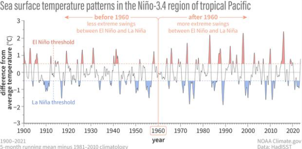
Figure 2: SSTs in the El Niño 3.4 region from 1900 to 2023. Note increased volatility in the time series post 1960. Source: https://www.climate.gov/news-features/blogs/enso/has-climate-change-already-affected-enso
These modelled impacts remain highly uncertain in extent and timing because the phenomenon is highly complex and observational data is incomplete. To this end, the emphasis on large multi-model ensembles (such as those that form the Coupled Model Intercomparison Project (CMIP)) should be weighed against improved representation of ENSO through higher-resolution and fidelity Earth System models that improve cloud, cryosphere and soil moisture interactions. In addition, the dismantling of the Ocean Observatories Initiative (OOI) network, which collects real-time data on marine heatwaves and sea surface temperatures, does not bode well for further progress in our understanding of ENSO. Instead, given the profound and far-reaching societal impacts of ENSO, continued investment in climate research and monitoring is essential.
Similar to the section above on historical ENSO impacts, the breadth of the topic means that we will not be able to cover the wide range of variables and regions of interest here. Instead, we offer high level perspectives about the current evolution of the ENSO event itself such that readers can critically interpret regional / local authority dynamic seasonal forecasts (which ought to already consider ENSO influence).
Firstly, as we are well past the April predictability barrier, there is high confidence in both the type and strength of El Niño that is evolving. Unlike the 2014-15 predicted Super El Niño event, which dissipated by SON, there is significant climate momentum in this event evidenced in part by the sea level temperature and surface height anomalies sensitive to warm water expansion. The magnitude and spread of SSTAs suggest that the current event may most resemble the major 97-98 event, yet there are important nuances as the classic early Eastern Pacific Pattern gives way to a hybrid like system with Central Pacific Warming by the end of the year.
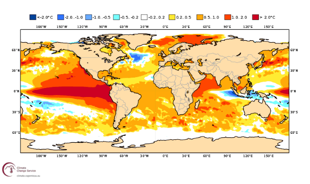
Figure 3: Projected SSTAs for October from ECMWF- note the large warm pool of anomalies that extends beyond the East Pacific and into Central and Northern Pacific regions. Source: ECMWF
While there may be no exact historical analog in which impacts can be readily inferred, the characteristics of the current event hint at the following across the APAC region over the next three to six months (July through to December).
| Variable | Expected Impact | Comments |
| Rainfall | Abrupt switch to drier conditions | For Australia, a later-than-usual drying effect, but when it does occur, an abrupt shift may take place, particularly in the South-East. Due to higher pre-existing soil moisture conditions, risk of large bushfires (similar to 2019) will take months to evolve and is unlikely over the SON period; instead, we may see more multiple fine fuel fires. Strong drying effect is likely to take place across Indonesian and Philippines archipelagos, raising peat forest fire transboundary haze pollution (from Indonesia), and water scarcity risks. Reduced rainfall in Vietnam may in turn lead to reduced river flow and exacerbate existing salt-water intrusion issues in the Mekong Delta. |
| Temperature | Overall warming | Generally elevated temperatures expected across most parts of APAC. An especially mild Australian winter is already evidenced through lack of snowfall. Thailand and Vietnam, already reeling from heatwaves in recent months, are unlikely to get respite through a weaker monsoon, reduced cloud cover and hence increased radiation. The picture for Japan is more nuanced – with elevated SSTAs likely to more than offset the cooling effect due to a shift in the position of the sub-tropical high. As a result, the recent cooler conditions in early summer are expected to give way to above-average late summer into autumn high temperatures. |
| Typhoons | Fewer expected, but more intense and a shift in maximum impact areas | As the typhoon season progresses, the main typhoon development region is expected to shift further East, with bias of storms towards recurving North / North-East. This may be welcome news for Vietnam, which was impacted by successive typhoons that persisted even late into the year, but not so much for Japan (similar to when it experienced highly damaging typhoons in 2019, weak El Niño), where multiple landfalling typhoons have already occurred early in this season. Although the overall number of storms formed may not increase, the increased intensity (as it travels longer). |
Read part one: Return of the Damned Child: Understanding ENSO in a Changing Climate .
Ashok K. et al., El Niño Modoki and its possible teleconnection, Journal of Geophysical Research, 2007
Cai W., et al., Changing El Niño Southern Oscillation in a Warming Climate, Nature Reviews Earth and Environment, 2021
McPhaden M. et al., Introduction to El Niño Southern Oscillation in a Changing Climate, Geophysical Monograph Series, 2020
Pui A., et al., Impact of the El Niño–Southern Oscillation, Indian Ocean Dipole, and Southern Annular Mode on Daily to Sub-daily Rainfall Characteristics in East Australia, Monthly Weather Review, 2012
Pui A., et al., Haze Risk in South East Asia: An Insurance Solution, Swiss Re Sigma, 2018
Risbey J., et al., On the Remote Drivers of Rainfall Variability in Australia, Monthly Weather Review, 2009
The views expressed in this article are those of the author(s) or working group named below, and do not necessarily reflect the views of the Actuaries Institute. This work is licensed under a Creative Commons Attribution-NonCommercial-No Derivatives CC BY-NC-ND Version 4.0.


From physical risk modelling to transition pathways, explore our latest thinking on climate and sustainability
Subscribe to Actuaries Digital for free and receive the latest actuarial analysis, research, and commentary direct to your inbox